Tuesday 4 November 2014

Feedback Seminar 3


 Visual
·      Flatten a few patches to remove a few texture patches. Too much texture is distracting.
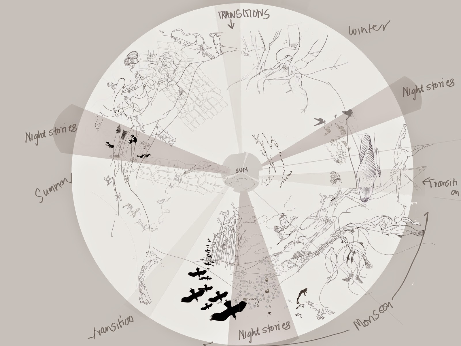
·      How does one identify the season change/ transition spaces?
·      Balance between illustration and information design through clarity in the activities happening in the map.

Text
·      Having text in the map to support the visuals can be looked at. A separate form can become unnecessary. The text will also help the viewers to understand/communicate information and make it look more like a map.
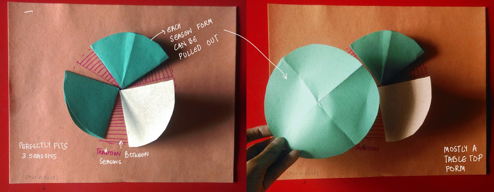
Form:
·      A simple mechanism like rotation will be interesting to play around in the form.

Presentation skills
·      To spend more time talking about the stage the project is at, then the process while presenting.
·      Could have started by sharing the final work first and also a quick introduction where your own personal interest lies in this project.


Monday 20 October 2014

Thursday Feedback sesssion

1. Use the grid to show the layers once everything is mapped and rendered which will then add elements of map and guide the viewer
2. The need of text in another form.
3. Use of vector is a good idea to show far away things.


Presentation

Begin the presentation where the project is at.
Introduction is a must and always speak as the project.

Work in progress

The grassland map,


Monday 6 October 2014

Session2

Anu's Feedback

1. Making smaller connections(stories) in the whole narrative so that you can read the narrative in different ways
2. Probably no need for text on map


Presentation skills need to be improved. Brief introduction to the project and the client is a must.

Friday 26 September 2014

Explorations

Explorations for the sky and the ground


Saturday 20 September 2014

Friday 19 September 2014

Feedback

Feedback from Sonali,


  • Categorised the content


  • Probably create personas for the target audience to understand:


  1.  If the same circular structure can be converted into different forms 
  2.  kind of information to offer for the different target audience

  • Continue prototyping 


Thursday 18 September 2014

Work in Progress


Need to have a more simplistic style with lesser strokes and may be a simple vector to show the symbols, signs.
I realised that some facts/stories need explanation and hence another small form is necessary.
Focusing on the idea that this is map which is also the index while designing it, adds other layers of maps such as landmarks, nodes,  edges, paths and districts subtly in it.


Also, I was trying to play around with grids and how can I use the grids


Sunday 14 September 2014

Friday feedback sessions

Points highlighted

In the previous as well as this feedback session, the history of grasslands was discussed and hence the need to represent it in some way in the form should be looked at.

Importance to humanity- bringing in some connection with the humans through this data
How is it impacting humans? "So What?"

Bringing in the Identity of Agumbe grasslands

Showing atleast one Complex food web
and not being bias to one season. Hence focusing on all the seasons.

Instead of how to unpack the grasslands,  the concept of revealing and discovering the grassland could be focused on.


Visual ideas:
Different sized of grids could be used
The visual style can also determine the audience


Exploring form


Possibilities of the form around the concept of unpacking the grasslands and to take the viewer deeper into the grassland through simple interaction is explored here.

The big circular map could act as an index and for further information, it could take multiple other forms. The other forms could be also be in circular shapes or a big book and all of this further unpacks to smaller details in flaps


Quick explorations,


Drawback:

  • Four seasons is a must
  • Size restriction due to folding and unfolding
  • Each circle unfolds into semicircle and then into another circle, hence each section needs to be filled
  • Not so much content


Drawbacks
  • Size restriction
  • Each circle unfolds into semicircle and then into another circle, hence each section needs to be filled
  • Not so much content


Drawbacks
  • Size restriction
  • Too much playfulness might be distractive
This form has multiple layers which takes the audience deeper through perspective and depth.

Saturday 13 September 2014

Quantifying content

Quantifying content into three stories per season and layering it with information such as

  • Journey- Start and end of the species journey in the grasslands
  • Activities- Breeding, Feeding, Resting
  • Sky-Ground connection- How do they use the grassland?
  • Sound- The different kind of sounds/silence experienced
  • Nature's Conditions- the required climate for the activities to take place
  • Personality/Metaphors
  • Growing stages
  • Existence of other species around them and Interaction
  • Unknown/Unexplained/Magical facts
  • Human intervention
  • Variation/size-scale
Mapping these layers into the structure:


Rough representation of one of the events into layers in the structure


Feedback: The style of this representation gives a playful(for kids) tone which may not work.


Rough mapping of Monsoon cycle

Saturday 6 September 2014

Friday Feedback sessions

Things to work on:

Quantify the content
Overall tone/feeling of the form

Prototypes of the structure based on the idea of unpacking the grasslands


Potential Points:
The circular map being the index( for further information)
Magical moments in stories which can lead to clues for interaction
Voices in each story
Start and end of stories/Journey
Transition between seasons

Visual Ideas:
Having species/activities coming in and going out of the circle.
Stages of the species could be visualised represented around the circle


Monday 1 September 2014

Initial skectches


Fishes in shallow water


Dark monsoon night


Sunday 31 August 2014

Exploring Structure

Circular form to show the changes and to map the biodiversity of grasslands is one of the form that I am looking forward to explore.

Can I unpack the grassland using this form? (will be exploring further the structure)

The sky lies in the centre and the earth/ground around it.

All the activities are related to the growth of the grass.

The grid can be further explored to map/spot different activities of species.


Mapping/zooming into one of the seasons- post monsoon


Exploring through grids- 
the mini stories, events/phenomenas, cycles


Moisture content in soil,

Exploring a part of the circular form


Analysing

After analysing primary research from Agumbe, the information can be categorised into,

Mini stories
1.     One of the few stories is that of, flock of birds flying towards the grasslands for food. Some species eat the fruits and hence while eating from the fruiting tree, the bees from the trees fly in open spaces that give food to other species of birds
2.     Smaller ecosystem in the waterfall- Rock, Algae, water and fish
3.     The migratory dragon flies, bees pollinating and attracting other species
4.     Fishes migrating from perennial water bodies to the first order streams for breeding
5.     Water flows from higher ground to lower ground during the monsoon to form the 1st order stream, which forms a breeding ground of many amphibians.
6.     Hundreds of flowers growing post monsoon in the grasslands attracting several species of butterflies and hence other birds who eat butterflies


Events/Phenomena
1.     Communal Breeding of common India toads which takes place during the first showers of monsoon
2.     Endemic species
3.     Best place and time to spot birds/species
4.     Dead tree which exits near a pond and a few species like eagles, snakes have been spotted
5.     Researcher’s track/path

Cycles- such as breeding, feeding and behaviour of certain species, changes in the grass throughout the year

(Monsoon Winter Winter-summer Summer)

Some of words that struck me while mapping my experience in the grasslands which I would like to take it forward in my form,

Feedback sessions


Session with Rustam

Rustam shared with us an interesting connection between humans being biped and grass. Humans when started hunting, which mostly happened in open areas like grasslands, needed better vision while they ran behind animals to hunt. Slowly their back posture began to change as they ran on the grass to hunt.
Grass is also one of the fastest oxygen producers and hence very significant.
(History of grasslands)

We discussed about the following possibilities in the forms,
1.     Digital form vs print media
2.     The use of simple sound and light technology can enhance the form
3.     Getting interaction to print media can also be looked at
4.     Medium, which can be modified for different platforms

Slowly unpacking the grasslands like a treasure hunt is a good start.
Also a mix of structure (looking at the circular map, cross section mapping and aerial view) could be looked at.


Meeting and Feedback at Crock Bank

Meeting with Rom, Gowri and Dhiraj helped to clear certain thoughts, which were floating around. A physical form will be more helpful than a digital form as it depends highly on technology. Also, a form that enables the viewers to get a glimpse of the message if in two minute and more depth information if further viewed.

This could be a good constraint and challenge to the form.